Cold Front Clearance
Next up in our 25th anniversary celebration series of weather phenomena, we will be going through frontal systems, and more specifically a cold front clearance.
One of the most important aspects when it comes to the weather we experience is how different frontal boundaries interact and move. With different masses of air behind them, when passing they often lead to sudden changes in temperature, humidity, cloudiness and wind direction. The UK is also in a prime position to consistently experience weather fronts, being an island with a large land mass to the east and an ocean to the west. Most fronts we experience are generated through the development of storms out in the Atlantic (see our post on Rapid cyclogenesis for more information on this) which then pass over the UK, bringing with them a range of weather conditions [1]. Seen on most surface pressure charts, like those provided by the Met Office [2], there are three very common frontal types, with one slightly rarer for the UK (stationary front) [1, 3]:
- Cold front – Drawn as blue lines with triangles pointing in the direction of travel, with relatively cooler air behind them.
- Warm front – Drawn as red lines with semi-circles pointing in the direction of travel, with relatively warm air behind them.
- Occluded front – Drawn as purple lines with both triangles and semi-circles pointing in the direction of travel, with cool air at the surface but warm air aloft behind them and occurs when a cold front catches up to a warm front.
- Stationary front – Drawn as intersecting red and blue lines with triangles and semi-circles pointing in opposing directions. These fronts don’t tend to move and have warmer air on one side, with cooler air on the other.
Have a go at pointing out the different fronts on the pressure chart (from Storm Goretti) below:
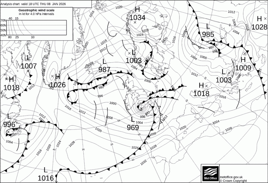
Specifically, a “cold front clearance” refers to the process in which a cold front passes, causing changes in the conditions felt at the ground surface. In a mass of relatively warm air, when a cold front approaches, the cooler and denser air acts like a snowplough, forcing the warmer air aloft. This causes moisture to condense out of the air, often leading to large amounts of cloud, rain, hail and even thunderstorms. Depending on the speed of the cold front (typically ~27 mph), these conditions can last for hours [3]. On top of this, squall lines, bands of incredibly sudden and strong winds and rain, can also be found on the leading edge of a cold front, and can cause damage to infrastructure if not prepared for [4].
The introduction of the relatively cold and dry air mass behind the cold front leads to a rapid decrease in both the temperature and humidity (which is very noticeable if you are outside). As the clouds dissipate, the intensity of the rain and thunderstorms also reduces, eventually revealing clear blue skies above. The air then remains cool and dry with strong gusty winds and very high visibility, often providing a ‘fresh’ feeling depending on the time of year [3, 5]. In fact, the conditions of a cold front clearance can be so dramatic that you can track a cold front clearing using a variety of different measurements from stations across the UK, and instructions on how to do that are found on the RMetSoc MetLink website linked below [6].
If you would like to find out more about fronts and their associated weather, please have a look through the links and references.
[1] Met Office (2026a). Weather fronts. Available at: https://weather.metoffice.gov.uk/learn-about/weather/atmosphere/weather-fronts (accessed: 11/06/2026)
[2] Met Office (2026b). Surface Pressure Charts. Available at: https://weather.metoffice.gov.uk/maps-and-charts/surface-pressure (accessed: 11/06/2026)
[3] Pilot Institute (2025). Weather Fronts Explained (Cold, Warm, Stationary, Occluded). Available at: https://pilotinstitute.com/weather-fronts-explained/ (accessed: 11/06/2026)
[4] Ceri Perkins – BBC Science Focus (2022). What is a squall line? Available at: https://www.sciencefocus.com/planet-earth/what-is-a-squall-line (accessed: 12/06/2026)
[5] BBC Bitesize (2026). Weather systems. Available at: https://www.bbc.co.uk/bitesize/articles/z62ncxs#zdmf9ty (accessed: 12/06/2026)
[6] Royal Meteorological Society MetLink (2026). Tracking a cold front. Available at: https://www.metlink.org/resource/tracking-a-cold-front/ (accessed:11/06/2026)