July and The Jet Stream

News / July and The Jet Stream

A tale of two Julys

Being the height of summer, July is normally one of the driest and warmest months of the year. In the East of England, it normally yields around 200 hours of sunshine, average temperatures in the low twenties and total rainfall values of 45-50 mm. However, the British summer is known for being extremely changeable, with some days having blue skies and sunshine and temperatures in the high twenties, and others having rain and temperatures in the mid-teens. One of the main drivers for this changeable weather is the Jet Stream. When located to the north of the UK, it often provides warm and dry settled weather from the continent, dominated by high-pressure systems. The opposite occurs when the jet stream is located either in line or to the south of the UK, bringing cooler temperatures from the maritime region, and lots of low-pressure systems (and therefore rain) from the Atlantic.

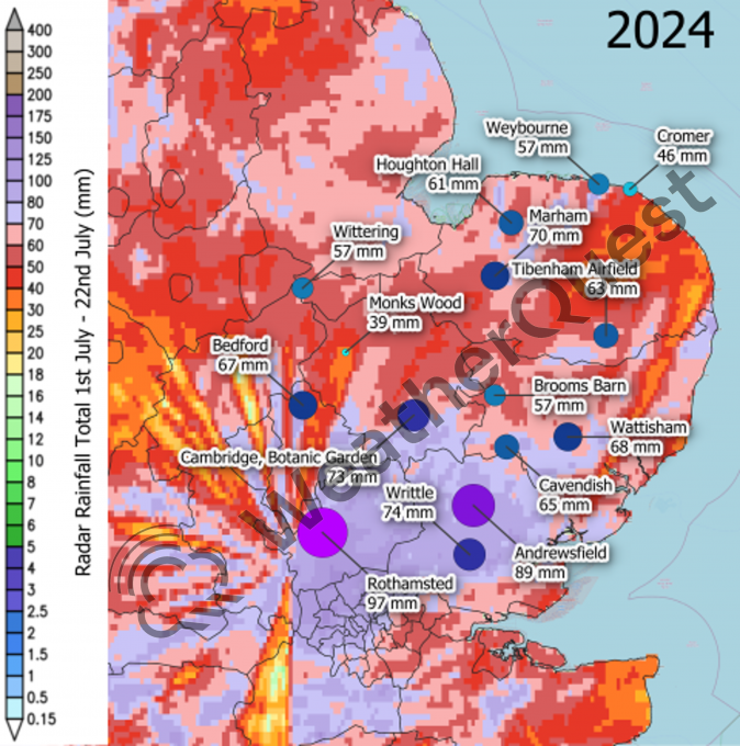
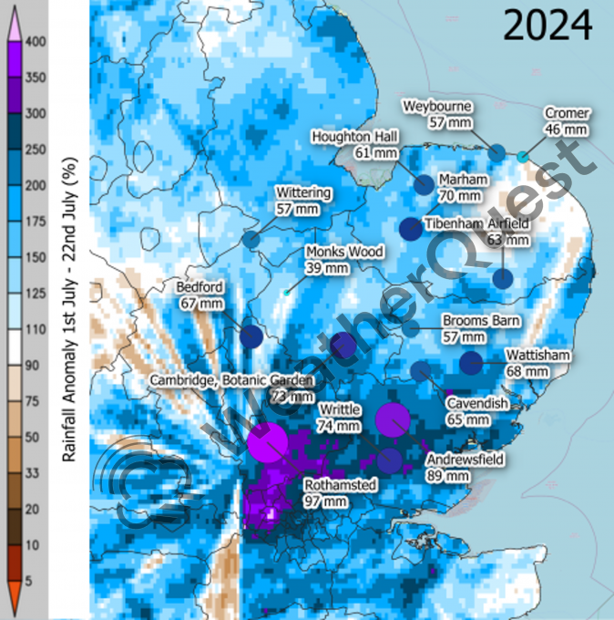
For the beginning of this summer the jet stream has been consistently stuck either over or south of the UK, providing the unseasonably cold temperatures and higher amounts of rainfall most of us have seen. It therefore goes without saying that this July has been wetter than average so far. In fact, when totalling rainfall values for the 1st-22nd, some areas are already matching or even doubling that of the average monthly totals (seen on the 2024 rainfall maps below). This is especially the case for some areas of West London, Hertfordshire and Essex, with station values reaching between ~87-100 mms; Ealing, West London, has had more than 4 times the average rainfall for July in just the first two thirds of the month. Due to the Jet Stream’s position, many storms and convective events have blown over the UK and looking at both maps, it seems that the convective storm tracks travelled consistently over the same area, leading to these incredibly high totals.

There was a change during the 18th-21st, where the jet stream to the west of the UK sank further south, before heading north again above the UK. This led to southerly winds, bringing with them hot continental temperatures and sunshine, with the warmest temperature reaching 31.9oC on the 19th at St James’s Park in London. This only lasted around three days however, when on Sunday 21st a weather front moved over the UK, reverting the jet stream to the pattern we have had for most of the summer so far, with it located just to the south of us and providing westerly winds and unsettled weather. Unfortunately, with no sign of this changing as we head into the latter stages of the month, wetter weather and cooler temperatures will seemingly close out July 2024, with August showing the first sign of more settled weather.

Only two years ago, in July 2022, it was an entirely different story. With a few heatwaves throughout June and rainfall values below average, the beginning of July started in a rainfall deficit. From the 1st to the 5th, it was cooler than average, but on the 6th of July, temperatures rose to ~2oC above average, and by the 10th many areas exceeded 30oC. This was caused by the jet stream over the Atlantic, which had a sharp southern dip over the ocean south of Greenland, leading it to head north above the UK. This kept the UK in a warm and settled region of continental air, with a high-pressure system that slowly moved across the UK, dominating the weather for a couple of weeks. Temperatures kept rising, with little to no rainfall across much of the UK, ultimately leading to the unprecedented temperatures seen on the 18th and 19th (40.3oC recorded at Coningsby).

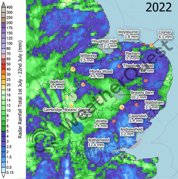
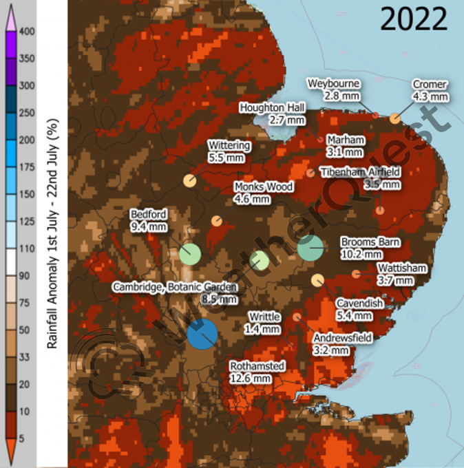
Despite being the same time of year as the 2024 example, you can see on the 2022 rainfall and anomaly maps above that many areas didn’t even reach 20 mm of rainfall (one fifth of the average monthly total) across the 1st-22nd July period and some areas of Essex, East London and the South received less than 5% of the monthly average. This led to widespread hosepipe bans, as water consumption skyrocketed due to the heat, whilst reservoirs and water resources dropped to incredibly low levels. There was also a record number of fires across the UK, and the London Fire Brigade had its busiest day since World War Two. After this period, the jet stream gradually shifted eastward, bringing average temperatures acorss the UK and slightly more unsettled weather towards the end of July and into August 2022.

These examples show just how changeable and different each year can be, bringing their own individual challenges. This changeability will increase into the future, as our climate continues to change. With global temperatures rising, the Jet Stream will have more energy, amplifying the frequency of its meridional flow (sinusoidal wave type pattern) state, increasing the chances of the jet stream being either north or south of the UK, and extreme events such as those mentioned will become more common. It is therefore incredibly important to improve the climate resilience of the UK, and WeatherQuest will continue to provide support for all our clients’ sectors going forward.

To find out more about our Climate services

Off to the EGU General Assembly!

News / The EGU General Assembly

Dan Smith, Research Meteorologist, taking part in EGU General Assembly

Later this April one of our Research Meteorologists, Dr Dan Smith, will be heading to Vienna, Austria, to take part in the European Geosciences Union (EGU) General Assembly conference. The EGU is one of Europe’s leading organisations for Earth, planetary and space science research, and has over 19,000 members from across the continent. Publishing a wide range of journals and organising meetings, education sessions and outreach activities, they aim to advance fundamental research that addresses key socioenvironmental challenges.

Each year they hold a General Assembly, a large week-long conference which encourages members and non-members to take part in the different programme groups available. There are main disciplinary sessions which cover topics decided by each different scientific division, transdisciplinary lectures, debates, short courses as well as education and outreach workshops all on different days throughout the week. Two main subjects, Ocean, and Atmospheric Sciences are of interest to Dan who splits his time being a Research Meteorologist with WeatherQuest and being a Researcher at the University of East Anglia (UEA). Some of the sessions in these subjects include:

  • Numerical Weather Prediction, Data Assimilation and Ensemble Forecasting
  • From mesoscale Convection to Convective-Scale Predictions: Advances in Process Modelling, Observations, Data Assimilation and Machine Learning
  • Forecasting the Weather
  • Subseasonal-to-Seasonal Prediction, Processes and Applications
  • Modelling and Measuring Snow Processes Across Scales
  • Aviation Meteorology, Nowcasting and the use of UAS for Atmospheric Sciences
  • Precipitation: Measurement, Climatology, Remote Sensing and Modelling
  • Clouds, Aerosol, Radiation and Precipitation interactions
  • Oceanography at coastal scales: Modelling, Coupling, Observations and Applications
  • Observing and Modelling the Imprint of Meso- and Submesoscale Dynamics
  • Open Session on Coastal and Shelf Seas
  • Eddies, Waves and Instabilities: Observing, Modelling, and Parameterizing Oceanic Energy Transfers
  • Observing, forecasting, and projecting the Global Coastal Ocean (CoastPredict)

Aside from this, Dan is presenting a poster in the “Aerosol Emissions and Properties, Ice Nucleating Particles, Cloud Processes and Radiative Feedbacks: From Observations to Modelling” session, linking to his research at UEA. By having Dan on the ground heading to these sessions, it helps keep us up to date on the current science, gives us ideas on how we can improve all our services, and whether there are any areas of research we could investigate. We look forward to hearing what Dan will learn from this trip!

To find out more about our Research and Development service

UEA Meteorology Field Course

News / UEA Meteorology Field Course

UEA students head off to the Lake District!

WeatherQuest has always had very strong links to the University of East Anglia and the School of Environmental Sciences (Env). Not only are we located on campus, many of our past and present employees are Env graduates and some are current members of the faculty, a lecturer and researcher. One such faculty member is our very own Chris Bell (CCO), who leads a module in Applied Meteorology for second year students. As part of the module, every year in mid-Spring Chris and the enrolled students embark on a week-long field course to the Lake District, with the main focus being the micro- and macro-meteorology of the area and Cumbria respectively.

At the beginning of the week, the students record what the computer forecasts are for the synoptic situation over Cumbria for the week, taking note of any changes and the general weather for each day (max and min temps and wind speeds etc). They then erect a weather mast in a location carefully chosen for its interesting micro-meteorology (e.g. downwind of a hill). This mast has an array of meteorological equipment attached, including solarimeters, wind vanes, anemometers and thermometers, with their measurements all being logged and recorded.

Throughout the rest of the week the students complete different meteorological activities, ranging from manual weather data collection (using hygrometers and anemometers), cloud observation exercises, launching a weather balloon, drone flying and met office station or other site visits. This year, it is planned that the site visit will be a walking tour of Keswick with the Environment Agency, talking about flooding and its impacts in the area. As the lake district is one of the wettest areas in the UK, flooding is a major issue in the national park and those who live in it. At the end of each day, the students then take part in a weather briefing, whereby they look at the current synoptic situation, forecast models and any weather warnings to create a presentation that they present to the rest of the cohort.

At the end of the week, the students collate the synoptic data from the week along with their logged weather mast micro-meteorology data in preparation for their assessments following the trip. Then on the final evening before heading home the next day, they take a well needed trip to the local pub, rounding the whole week off.

When home, the students then spend time completing their assessment. The first part involves comparing how well the forecasts at the beginning of the week matched the synoptic change experienced. They can then use this information to help with the second part, exploring how the micro-meteorology changed throughout the same period. They do this by completing complex calculations from the weather mast measurements, finding variables such as turbulence, sensible and latent heat flux and net radiation. They then relate this micro-meteorology to the synoptic changes (e.g. a cold front pushed through the lake district, causing the temperatures to drop along with a reduction in solar radiation).

Not only is this trip incredibly fun and informative for the students, but it also does help prepare them for a job in the world of occupational meteorology, which is very beneficial. Chris is looking forward to this year’s trip, with his fingers crossed for some interesting weather to occur!

To find out more about our Research and Development service

Vineyard Frost Protection Project

News / Vineyard Frost Protection Project

Some exciting news on the Frost Protection side of Agriculture!

We are taking part in an innovative frost forecasting and management project which has secured over £300,000 in funding from both Innovate UK and the Department of Food and Rural Affairs (Defra).

Working alongside TerraPrima, Agri-Epi Centre, Plumpton College, Vinescapes, Vinewatch and WineGB, the project is called ‘Smarter Forecasting, Communication and Management of Frost Risk in Vineyards’. The project will aid the rapidly growing sector of domestic viticulture in the UK and their resistance to frosts. By creating accurate, real-time, hyper-localised, site-specific, and variety-specific frost risk forecasts, it will enable vineyards managers to make more confident, informed and targeted decisions when it comes to frost mitigation, with the added benefit of sustainability in mind.

Sensors installed across a broad range of Vineyards in West and East Sussex, Surrey and Oxfordshire will be used to evaluate frost risk at an incredibly fine level. By utilising these on-site sensors and combining them with ever improving forecast models and site-specific mapped frost risk assessments, the project will launch fine resolution forecasts of both frost risk and frost type, which will ultimately be available through an app.

Due to the changing climate, Spring is undergoing some rapid changes, most notably its start date. With an earlier start to the warmer weather, it kickstarts the budburst on the vines – the time when vines are most at risk to frost damage. Unfortunately, even with this shift, temperatures can swing back to form sharp frosts which cause widespread damage. The number and severity of these frosts changes year to year, but the threat to UK vineyards remains the same.

With the help of this project, vine growers will be able to protect their crop in a more focused approach, understanding which mitigation method best prevents damage for the frost forecast conditions, reducing the stress of the frost season, and helping them make changes to better the environment. We are incredibly excited to be taking part!

Photo Credits:
Ridgeview Wine Estate / @juliaclaxton
Terraprima Group

To find out more about our Research and Development service

Agriculture Day at Norwich Science Festival!

News / Agriculture Day at Norwich Science Festival!

Norwich Science Week – Food and Farming!

On Sunday 18th Feb, the Norwich Science Festival held its day for all things agriculture, aiming to show all those who visited “the journey food takes, from fields, to farms all the way to the end of our forks”! Agriculture is one of the main sectors we supply a service for, so it was a pleasure to be invited to take part on this day.

We got the chance to show off some of our favourite weather instruments, including the anemometer (the fastest wind speed created by a visitor blowing into the anemometer was 74 mph – the equivalent of a storm!), whirling hygrometers (what we use to measure humidity) and the rather topical rain gauges (over the weekend, some parts of Norfolk saw more than 30mm of rain, leading to local flooding).

On top of this we had a display weather balloon (which in operation can reach heights of ~25 km –with the balloon reaching the size of a small car), three example radiosondes that would be attached to the balloon (normally measuring humidity and temperature, also containing a GPS for wind speed and direction) and a video of a balloon release. This generated a lot of conversation about how we use the data from weather balloon radiosondes, the five stations across the British Isles that release them and the worldwide balloon network.

This then allowed us to go into greater detail about how forecasts work, by measuring the current weather data, then inputting this to weather patterns and computer models to help determine what the weather will be, an hour, a day or even a week into the future.

Finally, we showed a couple of maps relating to our agricultural research, including the locations of vineyards across the UK, sparking conversation on how climate change will cause the suitable grape-growing areas to shift, causing more British vineyards to pop up in the future!

Overall, we at WeatherQuest had a fantastic time talking to all the visitors, letting them know a bit about forecasting and the role we play in the agricultural field (pun intended), so thank you for coming along and saying hi if you did! We also thank the Norwich Science Festival for inviting us and hope to return next year for more!